A map - ‘A Guide to Cycling in Warrington’ - has been compiled by Warrington Cycle Forum in conjunction with the Warrington Cycle Campaign and the Council.
Routes for every cyclist
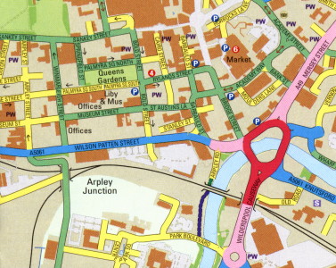
The guide uses the new standard in mapping routes for cyclists pioneered in Cheltenham. Instead of showing only specific cycle routes and other facilities, the map categorises the entire highway network according to the degree of skill and experience needed for cycling. In this way you can select the routes that are best suited to your personal preferences and ability no matter where you want to travel from and to in Warrington.
|
Download the Map |
Off-road routes and other cycle facilities
Although not a facilities map per-se, most cycle facilities in Warrington are shown on the map. Tarmac surfaced off-road routes are shown as green lines while unsurfaced surfaced cycle paths such as the Trans-Pennine Trail are coloured brown. Shared footways (pavements) are shown with a broken red line but should be used only with the greatest care, as there can be many hazards, particularly at junctions.Cycle parking locations are shown with the traditional P symbol throughout the town.
Information and advice
The reverse side of the cycle map contains useful information about cycling, including cycling for health, cycle training, and contact details of local cycling organisations and cycle shops.
To order your cycle map, contact:
Lesley McAllister
Phone: 01925 443243
Email: ltp@warrington.gov.uk
or visit you local library or leisure centre.